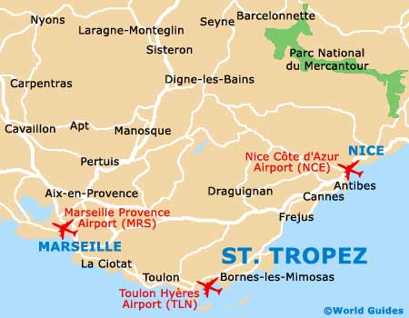
St. Tropez Maps and Orientation
(St. Tropez, Provence-Alpes Cote d'Azur, France)
A famous town basking in the sunny French Riviera, Saint Tropez has become a coastal retreat for many. This is due in no small part to Saint Tropez beautiful coastal location, being sited on the far southern shore of France, within the Var département (region).
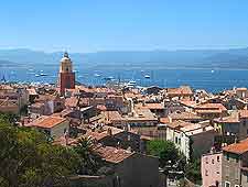
Saint Tropez enjoys a scenic peninsula setting, on the southerly side of its namesake, the Bay of St. Tropez. This is by no means a large town and has a population of just under 6,000 people. However, these numbers are greatly swelled by the influx of tourists, which are known to regularly include the rich and famous.
Maps and Orientation of the Town
Most tourists immediately head to the beaches, which begin around 4 km / 2.5 miles to the south-east of the actual town centre itself. The historic quarter known as the Old Town is well worth investigating at your leisure and lies between the main quay of the Vieux Port (the Quai Jean Jaurès) and also the town's famous square, the Place des Lices. The town's 16th-century citadel is close by.
For tourist information, maps and more, the Central Tourist Office of the Bay of St. Tropez / Pays Des Maures (Office de Tourisme) should be your first port of call. The office stands on the Quai Jean Jaurès and regularly organises walking tours of the town, which last up to two hours.
Office de Tourisme de Saint Tropez
Tel: +33 04 9497 4521
Fax: +33 04 9497 8266
Email: tourism@saint-tropez.st
Open hours: daily, July and August - 09:30 to 20:30; April to June / September and October - 09:30 to 12:30, 14:00 to 19:00; November to March - 09:30 to 12:30, 14:00 to 18:00
- Aix-en-Provence - 120 km / 75 miles (one hour and 30 minutes, west)
- Bormes-les-Mimosas - 38 km / 24 miles (40 minutes, south-west)
- Cannes - 85 km / 53 miles (one hour and 25 minutes, north-east)
- Cogolin - 11 km / 7 miles (18 minutes, west)
- Draguignan - 48 km / 30 miles (one hour, north)
- Gassin - 8 km / 5 miles (15 minutes, south-west)
- Grimaud - 12 km / 7 miles (18 minutes, west)
- Marseille - 150 km / 93 miles (one hour and 50 minutes, west)
- Nice - 112 km / 70 miles (one hour and 35 minutes, north-east)
- Nimes - 225 km / 140 miles (two hours and 30 minutes, west)
- Ramatuelle - 11 km / 7 miles (15 minutes, south)
- Saint Raphael - 35 km / 22 miles (55 minutes, north-east)
- Sainte Maxime - 7 km / 4 miles (20 minutes, north)
- Toulon - 70 km / 43 miles (one hour and 15 minutes, west)
Map of France

Map of Saint Tropez